Three Shires Head
· Visit the beautiful waterfalls at the point where Cheshire, Staffordshire and Derbyshire meet ·
About the walk
This pleasant circuit of a little over 4 miles takes you out to Three Shires Head and back. Taking in secluded river valleys, mature woodland, a couple of miniature waterfalls, open sheep pasture and heather moorland, there are also some gentle hills to stretch the legs nicely—285 metres (935 feet) ascent and descent in total. Could take as little as 1¼ hours if you don't hang about, but on a nice day there are plenty of excuses to dally, particularly at the packhorse bridge at Three Shires Head, so allow a good 2 hours.
The route remains within Cheshire throughout, but follows the county boundary with Derbyshire, and then Staffordshire, near Three Shires Head. Technically, you could stand with one foot in Cheshire, one foot in Derbyshire, and one foot a hand in Staffordshire, but you'll get very wet trying...
Need-to-know
- Free parking (car park has three picnic tables, but no toilet facilities; no height restriction; no overnight parking or camping). Sadly, there's NO PUBLIC TRANSPORT to this location.
- 4½ miles (7¼ kilometres) circular walk
- 2 to 2½ hours at a leisurely pace
- Mixed terrain (including rough rocky tracks, and boggy ground after rain); not suitable for wheelchair users or for pushchairs.
- 5 stiles (including one ladder stile)
Getting there
Start and finish at Clough House Car Park (arrowed on the following map). The following may help if you use a satnav:
- nearest postcode: SK11 0BD (this postcode is actually in Wildboarclough village, about 1 kilometre south of Clough House Car Park)
- Latitude, Longitude: 53.225, -2.020
- Ordnance Survey grid reference: SJ 987 698
Map & directions
This simplified map provides guidance for the route described — the numbers refer to the numbered steps in the walk description. This map is not suitable for detailed navigation, for which you should use a copy of the relevant Ordnance Survey map.
The Ordnance Survey map covers a bigger area along with important information such as place names, official rights of way, and areas of Access Land.
For this walk, the ideal map is the Explorer Series Number OL24: The Peak District - White Peak Area (Buxton, Bakewell, Matlock & Dove Dale), which includes the whole area of the walk at 1:25 000 scale (4 centimetres to 1 kilometre).

Contour interval: 10 metres; index contours, 50 metres. North at top (approximate).
Map data © OpenStreetMap and available under the Open Database Licence. Contains Ordnance Survey data © Crown copyright & database right 2015.
Base map generated by OpenOrienteeringMap (created by Oliver O'Brien). OpenOrienteering map is supported by British Orienteering.
IMPORTANT It isn't possible to park at or drive to Three Shires Head, which is some distance from a public road. The walk described below starts from one of the closest public car parks (at Clough House, near Wildboarclough).
Stage 1: Clough House Car Park to A54 road
-
Leave the car park by following the exit road beside the nearby farm buildings on the right. Before you reach the buildings, you will pass an information board on your left, which describes the natural features and wildlife of the area you will be enjoying on this walk.
-
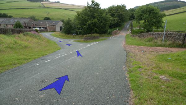
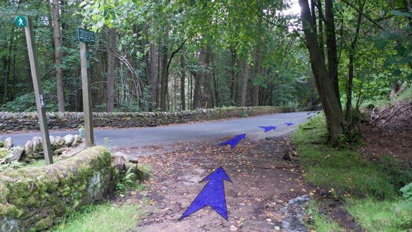
Approaching a triangular road junction (with a small tree on the central island, enclosed by a circular stone wall), keep right, then cross the road ahead to the left-hand gate. A Peak & Northern Footpaths Society sign (no. 104) marks the public footpath to "Cat & Fiddle Inn".
-
Go through the gate, and continue up the stony track ahead, with Cumberland Brook and farm buildings on your left.
-
Continue on the main track, crossing a footbridge over the brook and continuing up the main track on the other side.
-
Shortly after crossing the footbridge, go through a second gate on the main track. Continue on up the main track, climbing steadily now with woodland enclosing Cumberland Brook down to your right. The track is quite rough underfoot in places.

-
After about 250 metres, ensure that you keep right to stay on the main stony track where a grassy track bears left uphill to Cumberland Cottage.
-
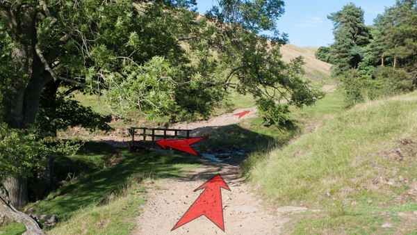
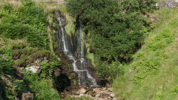
After another 400 metres of steady ascent on the stony track, you will leave the woodland behind, and a pretty waterfall comes into view ahead and to the right. (This fall may be absent following prolonged dry weather.)
-
As you approach the waterfall, go through a second gate, and follow the main track around to the right. This area can sometimes be quite wet underfoot.
-
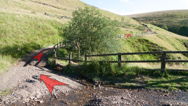
Cross the river behind the top of the waterfall, and continue to follow the main track up and around to the right (initially alongside a wooden fence), then gradually back left, all the while gently climbing across the open hillside. There are great views from here back down Cumberland Clough and over to Shutlingsloe.
-
Continue along the main track, very stony in places, still gaining height until you reach a stone building (Sparbent) on your right. From here, you can see the A54 Buxton to Congleton road (which you will soon cross) and "The Roaches", an obvious hill on the skyline in the direction of Sparbent. Breeding Curlews and Lapwings are frequent hereabouts from April to July.
-
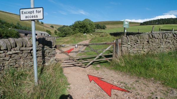
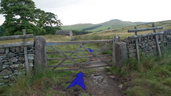
The track eventually reaches its high point just after Sparbent, and then descends slightly down to the A54. Go through the gate here, then carefully cross the road and climb over the crash barrier on the far side. Climb down the ladder stile onto a field.
Stage 2: A54 road to Three Shires Head to minor road
-
Walk a few metres down hill, crossing the narrow field, then use the stone step-stile to cross the wall.
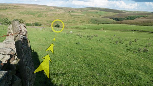
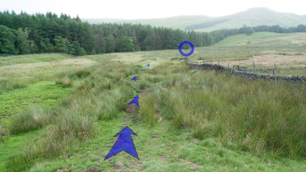
-
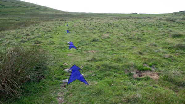
Having crossed the step-stile, the onward route isn't clear (there's no visible path across the grassy field). From the step-stile, bear left and head downhill, aiming in the direction of the isolated trees just behind a telegraph pole, visible in the valley below (circled in the photo). Continue in this direction until you reach an obvious broad grassy vehicle track crossing your path from left to right (about 150 metres from the step-stile). The track is sunken into the field, so you'll need to climb down a short bank to reach it.
-
On reaching the track, turn right and follow it to a gate between a stone wall and wire fence (about 50 metres).
-
Go through the gate, and turn immediately left.
-
Follow the track along a grassy terrace, slightly downhill, and never very far from the stone wall on your left. Keep clear of the low ground close to the wall and below the track, as this may be very wet.
-
After about 150 metres, pass a gate on your left (painted "PRIVATE"), and then follow the grassy track round to the right, passing a second gate on your left (also painted "PRIVATE").

-
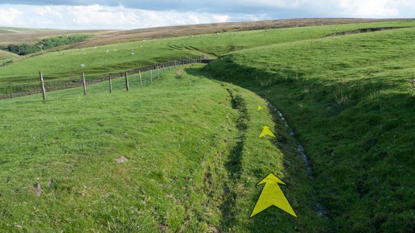
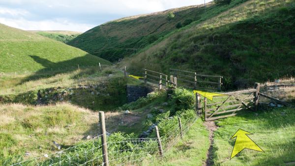
Continue along the grassy track (which can get quite wet in parts), as it stays close to the wall or fence on the left and gradually descends to the River Dane, curving right and reaching a gate after about 200 metres. The hillside on the far side of the river here is part of Derbyshire, the river marking the border between Derbyshire and Cheshire.

-
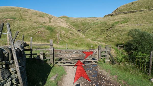
Go through the gate, and cross the bridge ahead. The path is now much narrower, rocky, and fringed with bracken (a lush green in the summer, turning golden brown in the autumn). After climbing slightly, the path gradually drops down to the confluence of the River Dane with an unnamed tributary (about 400 metres / ¼ mile) where you'll also see the old packhorse bridge ahead. Welcome to Three Shires Head!
-
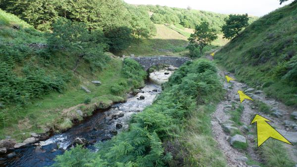
If the weather's fine, you'll probably want to spend some time at Three Shires Head. This is a perfect spot for a picnic, with grassy banks and rocky outcrops next to the river. Crossing the main packhorse bridge will take you from Cheshire into Derbyshire, then cross the second (smaller) bridge to pass from Derbyshire into Staffordshire. There are plenty of photo opportunities too, with the small waterfalls and pools making up a very pretty scene. When you're ready to go, be sure to continue along the same path that you arrived on, as there are many paths to different places hereabouts.
-
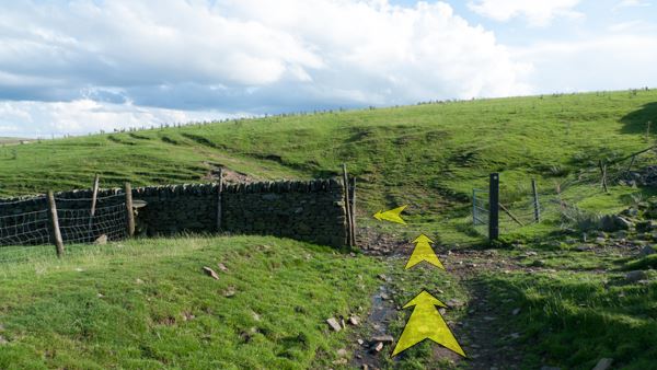
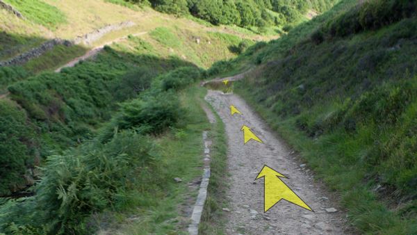
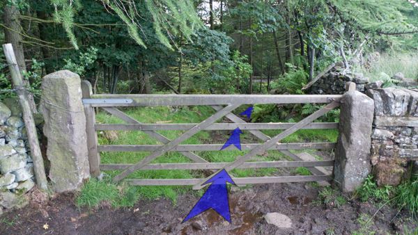
Continuing along the path that you arrived on (with the River Dane down on your left), follow the path as it gradually climbs and curves right. The path is slightly wider than previously, but still quite stony and rough underfoot. There are great views to the left here, over the Dane Valley towards Ramshaw Rocks and The Roaches. Continue along the main path for 1¼ kilometres (¾ mile), climbing gently all the while, until you eventually reach a gate across the track, just before a minor road.
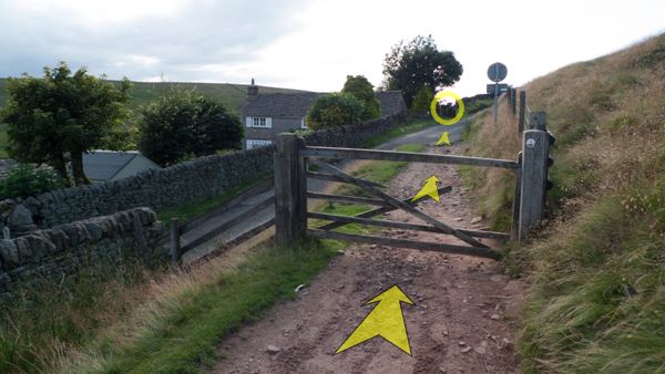
-
Go through the gate, then cross the minor road diagonally and go through a kissing gate on the far side (circled in the photo).
Stage 3: Minor road to Clough House Car Park
-
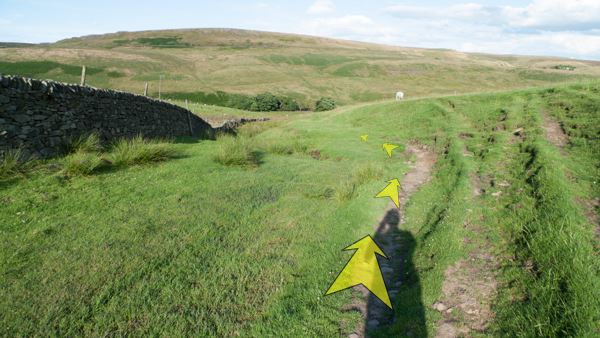
Having gone through the kissing gate, follow the grassy path across open ground, which curves to the right, and gradually climbs towards the ridge ahead. The ground here can get very wet and boggy in places after rain, and the path may be hard to follow. You've a good chance of hearing and seeing breeding Curlews here in the summer.
-
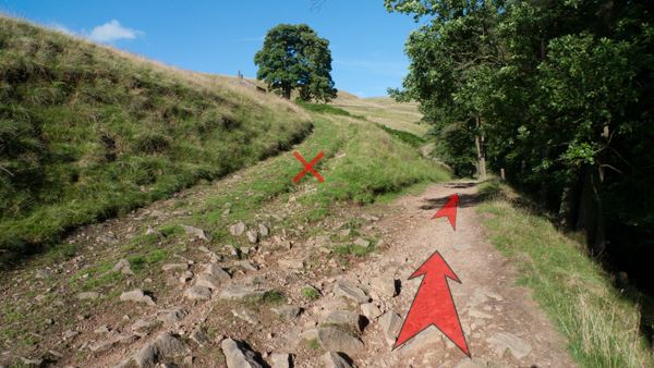
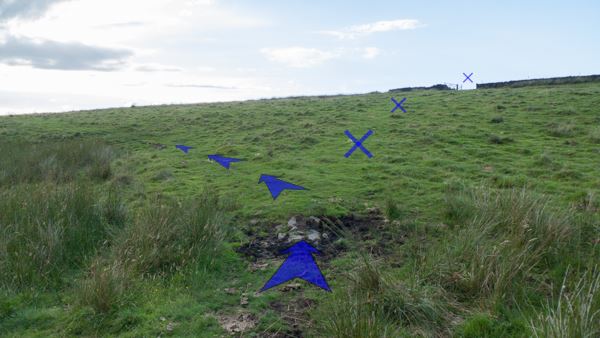
About 300 metres from the kissing gate, as the path rises towards an obvious gate on the horizon ahead, fork left onto another grassy path at an indistinct junction. Don't continue on the path towards the visible gate (marked with crosses on the photo), as this is not the right of way.
-
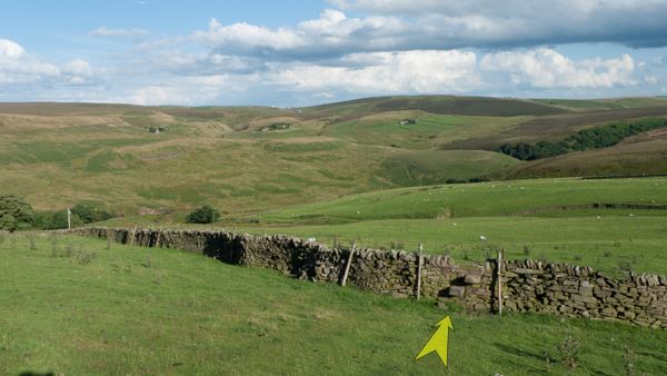
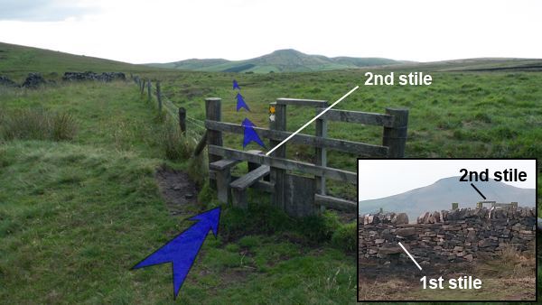
After about 100 metres, the path reaches the top of the slope and crosses a newly-built stone wall using a stone step-stile, followed by a fence with a second stile (and dog gate). Shutlingsloe (the obvious hill on the horizon) comes clearly in to view here. Cross both stiles, then bear slightly left to continue along the obvious grassy path, heading almost directly towards Shutlingsloe.
(Thank you to the walkpeakdistrict.com reader who sent in the inset photo showing the new stone wall and step stile.)
-
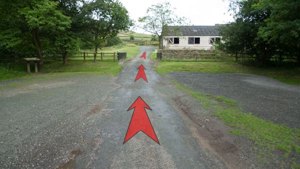
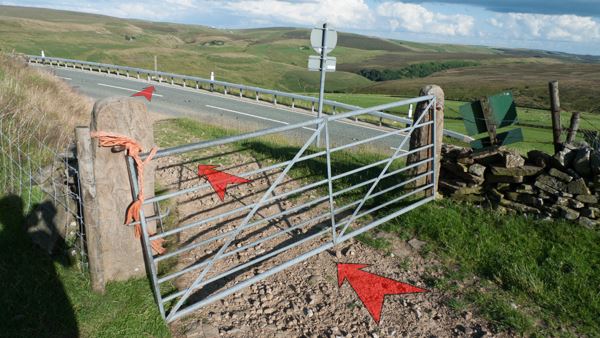
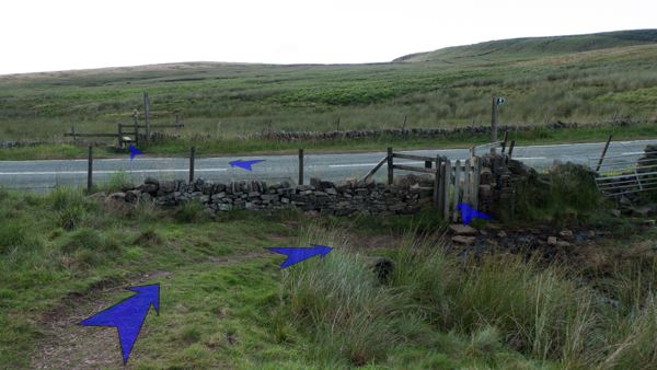
Continue along the grassy path (which can get quite wet underfoot after rain), crossing occasional planks over small streams and boggy areas. The path continues in the direction of Shutlingsloe (roughly northwest) for about 300 metres from the stile, before reaching the A54 Buxton to Congleton road (which you crossed earlier, nearer to Buxton). Go through a gate to reach the road, then cross the road and go over the stile on the far side. Take care crossing here; there's a blind bend to your left, and vehicles often travel quickly on this stretch of road.
-
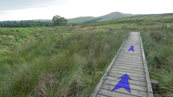
Having crossed the stile, continue along the well formed path, crossing first a long section of boardwalk, then two shorter sections. Despite the boardwalk, the path in this area can get very wet and boggy after rain. Continue along the path for about 150 metres from the stile, until you reach a gate across the track, just before a small stone building.
-
Go through the gate, and continue to follow the path, passing the small stone building on your left.
-
After passing the small stone building, continue following the path, gradually downhill now, until you reach a gate across the path at the edge of the forest, circled in the photo (about 200 metres from the building). This section of the path can be very wet and boggy after rain.
-
Go through the gate (often muddy beneath), and continue among trees down a very stony track for about 30 metres, until you meet a minor road. This short section of track can be quite wet and slippery, even after an extended dry spell.
-
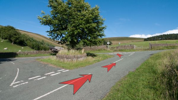
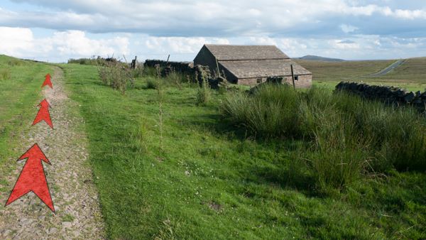
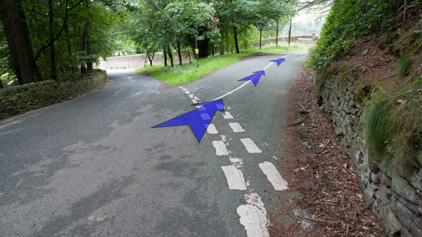
Turn right onto the road (next to a Peak District and Northern Counties Footpaths sign, number 132). Follow the road about 150 metres downhill to a road junction (ignoring the stony track that climbs away from the road to the right).
-
Turn right at the road junction, in the direction indicated by the road sign ("Macc. Forest 2¾"), and keep on the road as you pass the numerous buildings of Crag Hall on your left. Continue along the road as it gently climbs through a wooded area for the next 150 metres, then levels out a little after leaving the trees.
-
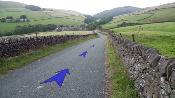
Continue along the road, which starts to descend quite steeply about 300 metres after leaving the trees. Clough House Farm and Car Park (your starting point), is now clearly visible ahead and to the left.
-
After another 300 metres on the road, you'll reach the entrance to Clough House Car Park on the left. If the weather's good, this is a pleasant spot (with picnic tables) to relax following your walk out to Three Shires Head and back.